There are three dominant rock types in this region: granite, sandstone, and limestone. You can see them in this picture from Timna when we visited.

The granites are the dark rocks on the left. The sandstone and limestone beds are the lighter colored rocks on the right in the background. The granites are about 630 million years old (about 1/7 the age of the earth). They formed as magma slowly rose from the mantle and cooled slowly under the crust. Over millions of years, that crust eroded away to expose them, and erosion continued on these crystalline blobs to produce flat land much like the topography of Australia. This is called the peneplain.

Notice how the red line skims just the tops of these granite mountains in Jordan just across the gulf from our apartment. These granite rocks are extensive and can be seen from space.
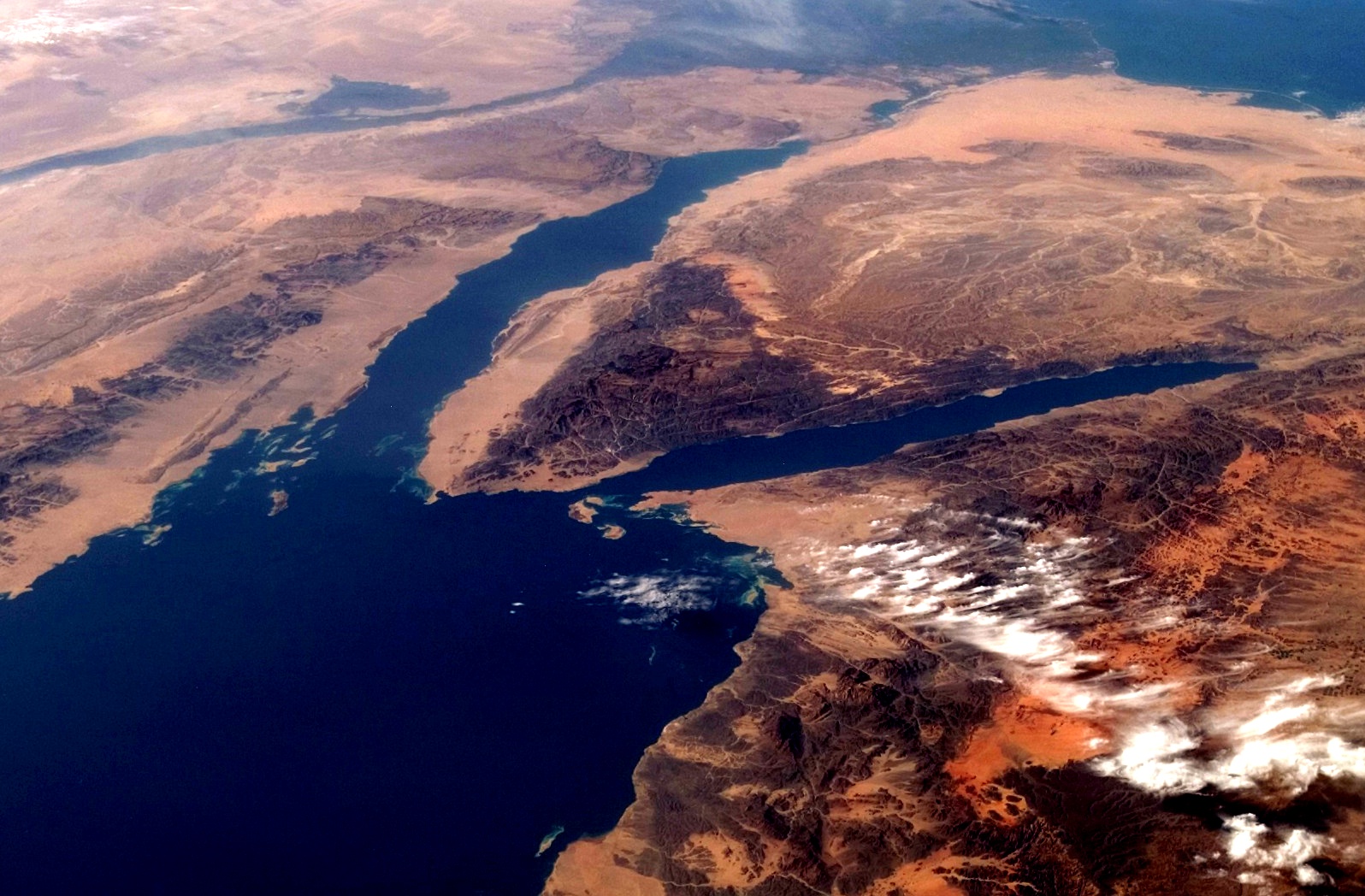
This picture of the Sinai Peninsula from Wikipedia shows the granites and sandstones. Egypt is to the left of the Gulf of Suez (left fork) and Eilat is at the tip of the Gulf of Aqaba (right fork). The dark rocks around the gulfs are the granites, and the lighter tan colors are the sandstones and limestones.
The sandstones and limestones indicate a shallow sea and coastal environment. These have been deposited over the last 500 million years or so. When sea level rises, limestones are deposited, and when it falls, sands encroach over the limestones, eventually hardening to form the sandstone. This produced the rock types seen here.

The story continues, however, with the start of East African Rift system about 25 million years ago. Convection from the mantle is slowly pushing up on the eastern side of Africa. As the heat spreads side ways, it pulls the continent in three directions and causes it to tear (called a triple junction). This is the same process that rifted Pangaea apart 175 million years ago. As the continent rifts, deep valleys open up and get flooded with seawater; this created the Gulf of Aden, the Red Sea, and, farther north, the Gulf of Aqaba. The process is still continuing, and 200 million years in the future this region will be on the edge of an ocean as vast as the Atlantic.
Nature doesn't like holes, though, so it fills them. Though the depression fills with seawater, the rocks themselves become unstable as the crust pulls apart. They crack and sink downward to create large fault blocks. Imagine a row of books slowly being pulled apart; those in the middle will slide to fill the space.
The sliding blocks create valleys and ridges (think of the Ridge and Valley province of Nevada). In geology, these are called horsts (ridge) and grabens (valleys). Younger rocks like the limestone and sandstone can slide downward and appear right beside old granites. This results in a color banding from ridge to ridge.
Notice how the mountains behind the buildings on the left from from dark to light to dark to light. The mountain peaks are split by these faults. The process is still going on today. About a week before we arrived, a relatively small 5.0 earthquake occurred as a block slide downward. This will continue to happen until the coasts move far enough away from the ridge to become stable many millions of years in the future.
No comments:
Post a Comment